ZARAUTZ
THE ZARAUTZ CHANNEL
The term “Channel” perhaps gives an idea of something great, but such isn’t the case. Despite calling Zarautz a “channel”, the truth is its quite small. The reason it is called a “channel” quite certainly dates back to the walls that were built in the 20th century to channel the river mouth.
In this environment the tide comes in quite powefully mixing salt water with fresh water. To the extent that it drags materials, sand, stones and various objects, and turbid waters, this daily disorder (twice salty, twice fresh, and then dry), makes it difficult for plant life; but not so the life of animals, since many different types inhabit it. The oportunistic species such as the seagulls gather in big groups, facing the wind with their beaks to comb their feathers. The godwits flutter around from side to side catching small insects in their beaks. Other bird species have colonised these warm waters eating everything. The remains of sea shells indicate the presence of other species. Plovers, bugs, snails or water fleas are typical creatures in this channel, and some leave their prints in the soft soil of this area.
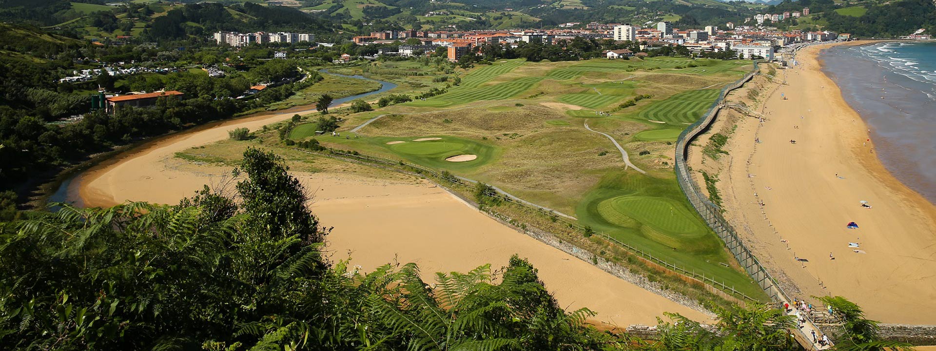
ZARAUTZ DUNES
The widest dune system of the province is located between the north side of the beach and the left side of the Iñurritza, with a surface area of almost 177,200 m2. The majority located within the golf course facilities.
A recently built walkway allows us to visit the dunes and plants, and with a little luck, we migh even see one of the small creatures.
These are weakly formed dune systems. As the plants are pulled out the sand is at the mercy of the wind, inevitably causing the dune to break up.
On this side of the dune, the plants that live facing the sea suffer much more due to the harsh storms.
The plants and animals of the dunes have to endure very adverse conditions and have a tough life. They have required several years of evolution to get used to this way of life, since it is an almost extinct way of life: very sunny during the day, they have serious difficulties in retaining water and the salt from the permanent wind makes the fine sand particles beat against the surface of their leaves.
The plants have had to search for different systems to find moisture in the deep sand and their leaves (as if they were sponges) in order to retain water, placing themselves as if they were small channels to direct the dew drops towards the plant stems.
The fauna of the dunes, the birds, reptiles, amphibians and small insects have adapted to the difficult conditions of this ecosystem, and much patience is required to see and observe them; since most mimic their surroundings and, if you do see one, do nott bother it, take a photo and take home a beautiful reminder.

ZARAUTZ MARSHLANDS
Although the Iñurritza marshlands are not very extensive, they maintain all the characteristics of the ecosystem. It is currently in a recovery phase and we all hope it will recover as soon as possible. People change, thoughts change, and what looked like a landfill a few years ago “the Zubiondo landfill”, looks different today.
The marshland vegetation is quite particular, and despite not possessing a great variety, is very rich, since only the plants that can withstand the two daily tides and are capable of coping with the salt trapped in the mud, but at the same time, have to adapt to the fresh water survive. The marshland vegetation plays a significant role in the biological cycle of the channel and the marshlands, and is essential for the fauna that inhabits it.
ZUMAIA
NATURAL ENVIRONMENT
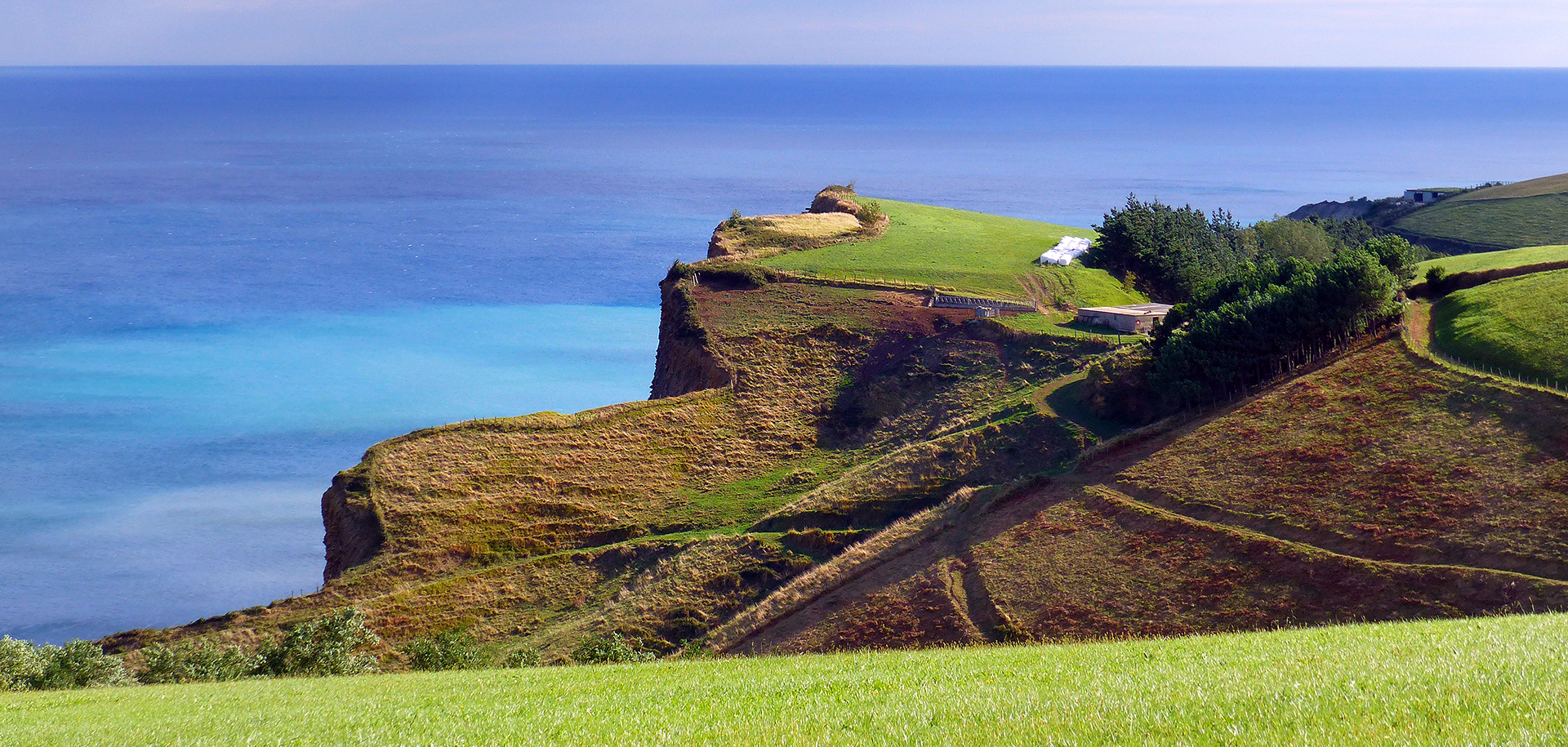
Zumaia is located on the west coast of Gipuzkoa, at the mouth of the Urola river. The town is surrounded by green mountains and a big blue sea. The power of the sea constantly shapes the coastline, and creates an incomparable landscape made up of spectacular cliffs and rock formations. In addition to this geological treasure, Zumaia contains different noteworthy formations and ecosystems of the Bay of Biscay. For example, the stunning intertidal abrasion platform between Deba and Zumaia (called a protected Biotope). An important place where the Urola Estuary joins up.
UROLA ESTUARY
The Urola estuary, located on the western-most part of the coast of Gipuzkoa, occupies the mouth of the Urola river between Oikia and Zumaia. This latter section of the river traces different meanders, protected on the east by the slopes of mount Artadi; the western coastline, on its part, reflects a gentle valley full of pastures, forests and partially urbanised marshlands.
Despite its small extension the enclave maintains a representation of the landscape of estuaries, even a variety of atmospheres, from the Cantabrian oak forest to the river forest sections, from the Mediterranean heath and moorland to the halophilous scrubs, and from the dune vegetation to the saline grasslands of the estuary.
In this environment protected by the Town Council by means of a special plan and integrated into the Natura 2000 Network, three main areas can be differentiated:
- The Santiago marshlands and dunes
- The holm oak groves of the Artadi district
- The meander and Bedua Islands
DEBA-ZUMAIA PROTECTED BIOTOPE
This protected coastline is located between Deba and Zumaia has a length of 8 kilometers and a surface area of 4,299 hectares. The biotope contains elements of great geological, landscape and natural interest as regards all the coastal ecosystems of the Basque Autonomous Community.
Among other things, the geomorphology of the coastal area should be mentioned, since it is exceptional from an international standpoint, but also the scarce anthropgenic change in the area should also be pointed out. It has an extraodinary geological interest, due to the large size of the intertidal abrasion platform it contains. This abrasion platform is made up from the characteristic erosion of the tertiary flysch materials and the transition areas that are significantly marked between the Cretaceous and Tertiary period.
The transitions between geological periods, the landscape and the nature itself offer the ideal conditions for it to be called a Protected Biotope, meaning, it is a particular, exclusive extension of stunning beauty and contains formations of great international scientific interest.